Measuring the size of the Earth
- Pictures
- Software
When
we started saying that we wanted to measure the size of the earth, our
friends wondered whether we were insane.
After all, if you really want to know it, you can simply check in any
basic atlas of astronomy.
But that was too
obvious. Instead we wanted to actually measure it ourselves, because we
were fascinated by the stories of those men who did the same thing for the
first time thousands of years ago.
We wanted to experience their same emotions as they were discovering more
and more about the world around them.
For instance that the earth is not flat but is rather a sphere and that it
can be measured using simple instruments available to everyone.
|
|
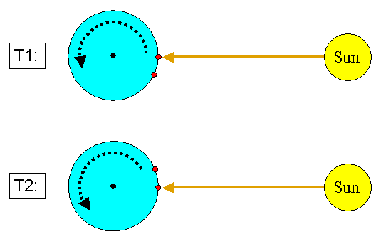 |
We decided to use the following method:
- chose two locations, possibly very close to the equator
and aligned more or less along the same parallel (= along a direction
east-west)
- measure the time when each of the two locations passes in
front of the sun (= local midday)
|
|
|
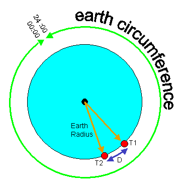
- calculate the time interval between these two events
- calculate the ratio between the time that the earth
takes to do a complete rotation (= 24 hours) and the above time interval
- measure the distance between the two locations
- calculate the earth circumference by multiplying this
distance times the above ratio
earth_circumference = D x
24_hours / (T2-T1) |
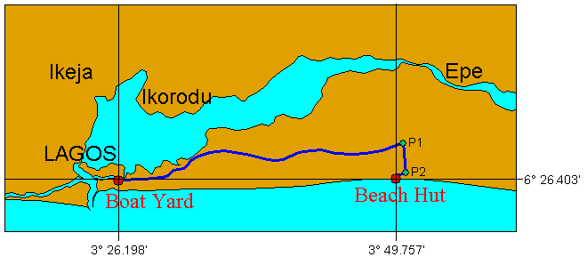
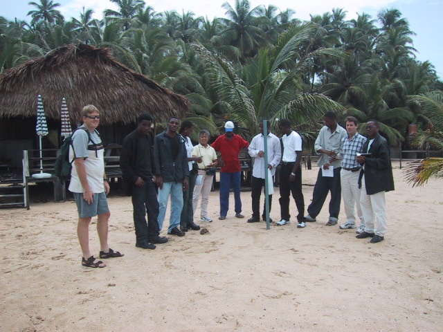
| Luckily we live in Lagos, which is only a little more than 6
degrees north of the equator. The two locations that we chose were:
- the Boat Yard "Knorr Marine", in Victoria Island
- the Beach Hut of our friend Vivian, at Eleko
We measured the distance between them using the odometer of our car:
- 0 km at the Beach Hut
- 2.9 km at P2 (entrance gate to Eleko Beach)
- 6.9 km at P1 (junction along the road to Epe)
- 55.8 km at the Boat Yard
The road is not very straight, but we considered this inaccuracy
acceptable for our method.
We did not count the piece of road between P1 and P2, because it runs
North-South.
We also removed the piece between the Beach Hut and P2 from the total
count.
The distance that we calculated was therefore:
(Boat_Yard - P1) - (P2 - Beach_Hut)
D = (55.8 - 6.9) - (2.9 - 0) = 46 km
We later checked on a map and we measured the actual distance of 43 km
between the two points.
Thus we were confident that our rudimental method was accurate enough. |
 |
|
|
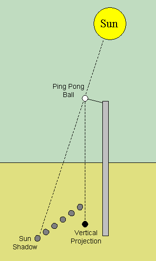
To measure the local midday we checked the time when the
length of the shadow of a certain object was shortest.
For this measurement we split in two groups. One stayed at the Boat
Yard and the other one went to the Beach Hut.
Each group set up a device that allowed to project a clear shadow of a
ping-pong ball onto the ground.
With the help of a plumb line we marked the position of the vertical
projection of the ping-pong ball on the ground.
Then we started to observe the shadow moving slowly and we marked its
position on the ground at regular intervals of five minutes. |
|
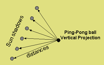
We marked the movement of the shadow for an hour and a
half and then we measured all the distances between each mark and the
vertical projection of the ping-pong ball.
|
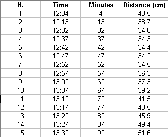
We prepared a table where, for each position of the shadow, we wrote down
the corresponding time and the distance.
|
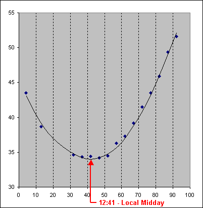
| And then we plotted the values on a diagram and we drew the
curve of best fit along the points.
Where the curve is lowest, there is the local midday.
For these data that were collected at the Beach Hut, one group
calculated the local midday at 12:41
Unfortunately no measurements could be taken at the Boat yard, because
it kept on raining all the time.
We decided therefore to get this second value using a software that
calculates the local midday of any place in the world, given the
coordinates of the place and the day of the observation.
With the help of a GPS we obtained the input data:
- Longitude: 3° 26.198'
- Latitude: 6° 26.403'
- Date: 11th May 2003
And from the software we obtained the local midday at the Boat Yard:
12h:42min:41sec or 12h:42.68min
In conclusion, the time interval between the local midday at the two
location is:
12:42.68 - 12:41.00 = 1.68 minutes
|
X axis: Time of measurement
Y axis: distance between Vertical Projection and Sun Shadow
|
At this point we had all the data needed for our final calculation:
earth_circumference = D x 24_hours / dT
D = distance between the two locations = 46 km
24-hours = 24 x 60 minutes = 1440 minutes
dT = time interval between the two locations = 1.68 minutes
earth_circumference = 46 x 1440 / 1.68 = 39350 km
earth_radius = earth_circumference / 2ϖ =
39350 / 6.28 = 6263 km
Considering that the actual earth circumference at the equator is 40075 km and that the actual earth radius is 6378 km, our calculation is only
1.8% off.
This was a great result and it concluded in the best way a fantastic day of
science and friendship.
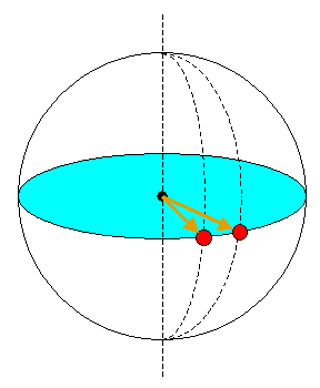
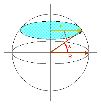
| What if you are not at the equator ?
The more you are away from the equator, the shortest is the radius that
you will measure with our method.
In this case you might need to correct your measurement (r) using the
latitude of your location (λ):
R = r / cos(λ)
We also applied this correction, but it turned out to be not very
significant, since we are so close to the equator.
The
average latitude of the Boat Yard and the Beach Hut is: 6° 26' = 6.43°
R
= 6263 / cos(6.43) = 6303 km |
|
And ... how do you know the latitude of your location ?
Well, you can simply read it on a map, but if you are a serious scientist then
you would measure it yourself, looking for instance at the North Star...
But this is a different story. For now enjoy a bit more of our experiment taking
a look at the PICTURES